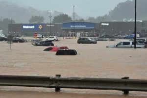
For the second time in eleven days, flash flooding tore through parts of the Upper Ohio basin, and the rain is not finished. A flood watch stretched across four states heading into the weekend.
Heavy rain on September 9 and 10 triggered repeated flash flood warnings across eastern Ohio, northern West Virginia, and parts of western Pennsylvania. On September 11 a flood watch expanded across Ohio, Pennsylvania, West Virginia, and Kentucky as more rain moved toward ground that is already saturated.
What happened
The National Weather Service issued a long string of flash flood and flood warnings through the nights of September 9 and 10, some covering the tri-state seam where Ohio, Pennsylvania, and West Virginia meet. Forecasters warned of continued flash flooding risk as storm cells trained over the same drainages. It comes barely a week after the storms that opened the month dropped two inches of rain in an hour on parts of our region and flooded eight counties.
Saturated ground changes the math
Back to back events matter more than either storm alone. Soil that is already full sheds nearly everything that falls on it, so streams rise faster and higher on less rain. Streambanks destabilized by the first event fail in the second. That is worth remembering both for safety and for what your group will see in the water: expect turbidity spikes, displaced woody debris, and possibly relocated monitoring equipment.
Why it matters for the rest of us
Three practical notes for member groups. First, stay off high water and remind volunteers that most flood deaths happen in vehicles. Second, once water recedes, check monitoring sites and photograph damage to trails, plantings, and restoration structures right away, since dated photos are the currency of every assistance program. Third, if damage is significant, report it to your county emergency management agency even if it seems minor, because county totals are what unlock state and federal recovery help.
Sources: WOWK-TV and a September 11 flood watch summary, drawing on National Weather Service warnings of September 9 and 10, 2026. Conditions may change; follow your local NWS office for current warnings.