A restored wetland is not a sponge you set down and walk away from. Where the water enters, how long it lingers, and which pools it actually reaches all decide how much fertilizer runoff the wetland catches. A new study out of Bowling Green State University, shared by Ohio Sea Grant, used 3D modeling to show that some of the best fixes are also some of the cheapest.
Researchers led by Dr. Ganming Liu of Bowling Green State University built 3D models of surface water, groundwater and nutrient movement at two H2Ohio wetland projects in northwest Ohio: the Forder Bridge Floodplain Reconnection Wetland in Paulding County and Oakwoods Nature Preserve in Findlay. Paired with on-site monitoring, the models showed that wetlands remove more phosphorus and nitrogen when their pools are better connected, when more nutrient-rich water is steered into pools that sit idle, and when water is kept from flowing back out too quickly. The team also built a tool to rank which lands are best suited for future restoration. The work was funded through the Harmful Algal Bloom Research Initiative (HABRI).
What the models showed
Wetlands vary enormously by soil, plants, design and how water moves through them, so two restored wetlands that look alike on paper can perform very differently. The Bowling Green team used weather data, topography and site conditions to simulate how water and nutrients actually travel through the two sites, including underground flow that no one can watch directly.
The simulations pointed to three practical improvements. First, connect the wetland’s pools so water can move between them. Second, route more of the nutrient-heavy water into depressional pools that otherwise sit mostly unused. Third, increase residence time, the length of time water stays in the wetland, by preventing short-term backflow to the source. None of these require a new wetland. They are adjustments to the ones already built.
Better connected pools, more water sent to idle pools, and longer residence time, all suggested by the models to boost nutrient removal in existing wetlands.
Picking the right places to restore
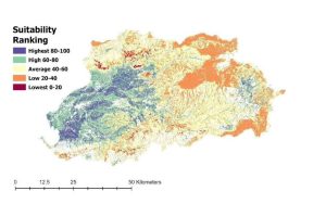
The team also developed a multi-criteria evaluation approach to quickly sort out which lands are suitable for new wetland projects, and tested it in a northwest Ohio watershed to produce a ranking map. Ohio Sea Grant notes the project’s products could save agencies time and money by getting wetland design right the first time.
“Our findings emphasize the need for continuous water-quality monitoring in restored wetlands and the precise alignment of pumping schedules with fluctuating nutrient levels.”
Dr. Ganming Liu, Bowling Green State University
Why it matters for the rest of us
This study was built around Lake Erie and the Maumee River, but the lesson travels. Nutrient runoff is a basin-wide problem, and the Ohio River saw its own harmful algal bloom stretch for hundreds of miles in 2015. As more wetland and floodplain restoration projects take shape across the basin’s farm country, every one of them will face the same question: is it built and managed to actually catch nutrients, or just to hold water?
For watershed groups and conservation districts planning or tending restored wetlands, the takeaway is refreshingly practical. Watch where the water really goes, keep monitoring after the ribbon cutting, and look for small changes in connectivity and flow before assuming a site needs a big fix. A wetland that gets a second look tends to earn its keep.
Read the Ohio Sea Grant Article
This article is based on reporting by Hayley Meyer for Ohio Sea Grant on a Harmful Algal Bloom Research Initiative project led by Dr. Ganming Liu of Bowling Green State University, published October 18, 2026. Current as of October 28, 2026.